Loading...
Searching...
No Matches
◆ RASTER_fromGDALRaster()
| Datum RASTER_fromGDALRaster | ( | PG_FUNCTION_ARGS | ) |
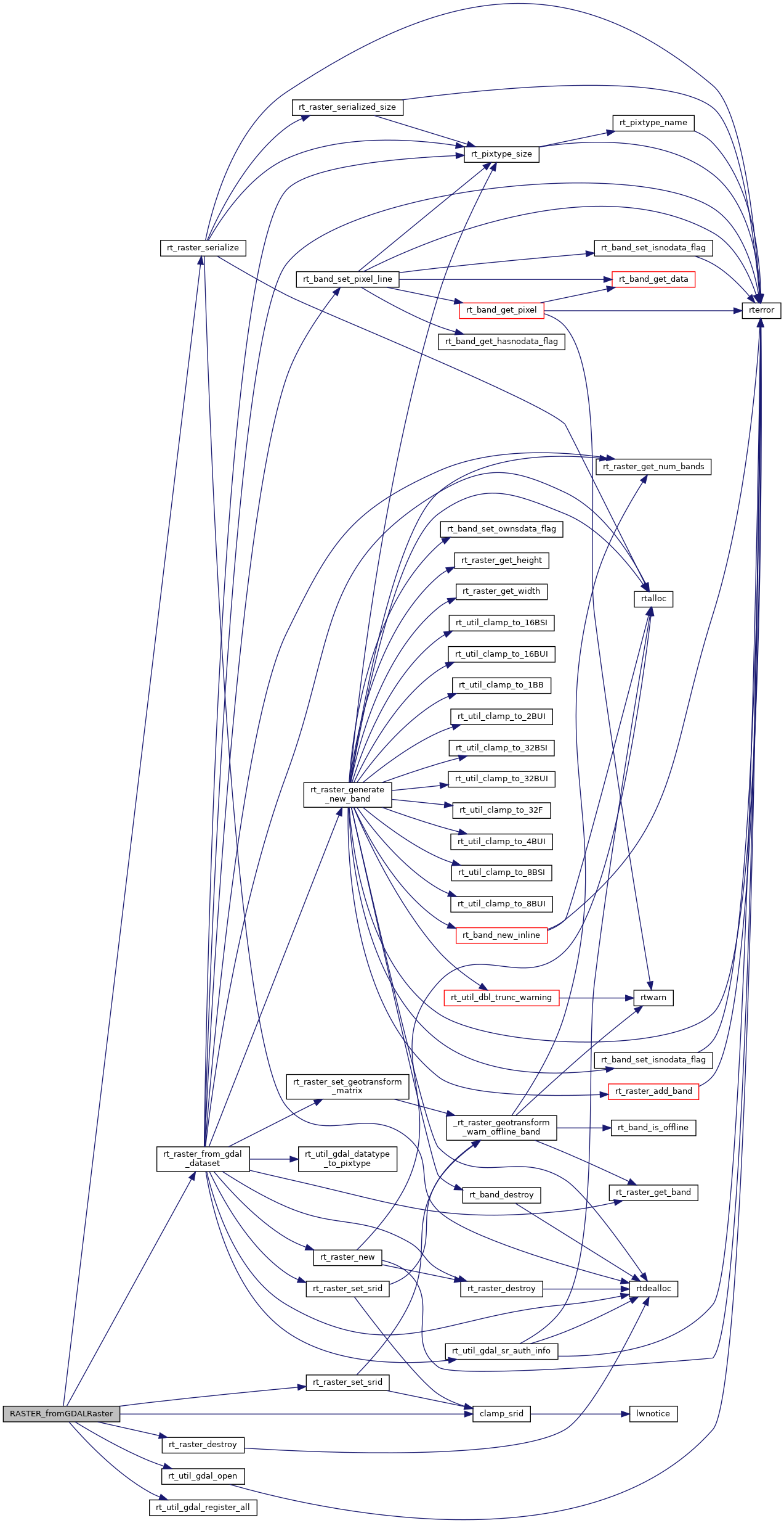
Definition at line 61 of file rtpg_gdal.c.
62{
63 bytea *bytea_data;
64 uint8_t *data;
65 int data_len = 0;
66 VSILFILE *vsifp = NULL;
67 GDALDatasetH hdsSrc;
68 int32_t srid = -1; /* -1 for NULL */
69
70 rt_pgraster *pgraster = NULL;
72
73 /* NULL if NULL */
74 if (PG_ARGISNULL(0))
75 PG_RETURN_NULL();
76
77 /* get data */
78 bytea_data = (bytea *) PG_GETARG_BYTEA_P(0);
79 data = (uint8_t *) VARDATA(bytea_data);
80 data_len = VARSIZE_ANY_EXHDR(bytea_data);
81
82 /* process srid */
83 /* NULL srid means try to determine SRID from bytea */
84 if (!PG_ARGISNULL(1))
85 srid = clamp_srid(PG_GETARG_INT32(1));
86
87 /* create memory "file" */
89 if (vsifp == NULL) {
90 PG_FREE_IF_COPY(bytea_data, 0);
91 elog(ERROR, "RASTER_fromGDALRaster: Could not load bytea into memory file for use by GDAL");
92 PG_RETURN_NULL();
93 }
94
95 /* register all GDAL drivers */
96 rt_util_gdal_register_all(0);
97
98 /* open GDAL raster */
100 if (hdsSrc == NULL) {
101 VSIFCloseL(vsifp);
102 PG_FREE_IF_COPY(bytea_data, 0);
103 elog(ERROR, "RASTER_fromGDALRaster: Could not open bytea with GDAL. Check that the bytea is of a GDAL supported format");
104 PG_RETURN_NULL();
105 }
106
107#if POSTGIS_DEBUG_LEVEL > 3
108 {
109 GDALDriverH hdrv = GDALGetDatasetDriver(hdsSrc);
110
112 GDALGetDriverShortName(hdrv),
113 GDALGetRasterXSize(hdsSrc),
114 GDALGetRasterYSize(hdsSrc)
115 );
116 }
117#endif
118
119 /* convert GDAL raster to raster */
121
122 GDALClose(hdsSrc);
123 VSIFCloseL(vsifp);
124 PG_FREE_IF_COPY(bytea_data, 0);
125
126 if (raster == NULL) {
127 elog(ERROR, "RASTER_fromGDALRaster: Could not convert GDAL raster to raster");
128 PG_RETURN_NULL();
129 }
130
131 /* apply SRID if set */
132 if (srid != -1)
133 rt_raster_set_srid(raster, srid);
134
135 pgraster = rt_raster_serialize(raster);
136 rt_raster_destroy(raster);
137 if (!pgraster)
138 PG_RETURN_NULL();
139
140 SET_VARSIZE(pgraster, pgraster->size);
141 PG_RETURN_POINTER(pgraster);
142}
int32_t clamp_srid(int32_t srid)
Return a valid SRID from an arbitrary integer Raises a notice if what comes out is different from wha...
Definition lwutil.c:333
int rt_util_gdal_register_all(int force_register_all)
Definition rt_util.c:338
void rt_raster_destroy(rt_raster raster)
Release memory associated to a raster.
Definition rt_raster.c:82
rt_raster rt_raster_from_gdal_dataset(GDALDatasetH ds)
Return a raster from a GDAL dataset.
Definition rt_raster.c:2177
GDALDatasetH rt_util_gdal_open(const char *fn, GDALAccess fn_access, int shared)
Definition rt_util.c:383
void * rt_raster_serialize(rt_raster raster)
Return this raster in serialized form.
Definition rt_serialize.c:521
raster
Be careful!! Zeros function's input parameter can be a (height x width) array, not (width x height): ...
Definition rtrowdump.py:121
Definition librtcore.h:2285
References clamp_srid(), FALSE, POSTGIS_RT_DEBUGF, rt_raster_destroy(), rt_raster_from_gdal_dataset(), rt_raster_serialize(), rt_raster_set_srid(), rt_util_gdal_open(), rt_util_gdal_register_all(), and rt_raster_serialized_t::size.
Here is the call graph for this function: