18. 地理
坐标为“地理”或“纬度/经度”的数据很常见。
与 Mercator、UTM 或 Stateplane 中的坐标不同,地理坐标不是**笛卡尔坐标**。地理坐标并不表示在平面上绘制的距原点的直线距离。相反,这些球坐标描述了地球上的角坐标。在**球坐标**中 ,点由相对于参考子午线(经度)的旋转角度和相对于赤道(纬度)的角度来指定。
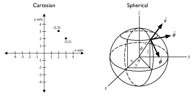
您可以将地理坐标视为近似笛卡尔坐标并继续进行空间计算。然而,距离、长度和面积的测量是**没有意义的**。由于球坐标测量**角**距离,因此单位为“度”。此外,索引和真/假测试(例如相交和包含)的近似结果可能会变得非常错误。随着接近两极或国际日期变更线等问题区域,点之间的距离会变得更大。
例如,这是洛杉矶和巴黎的坐标。
洛杉矶:
POINT(-118.4079 33.9434)巴黎:
POINT(2.3490 48.8533)
以下使用标准 PostGIS 笛卡尔坐标:command:`ST_Distance(geometry, geometry)`计算洛杉矶和巴黎之间的距离。请注意,SRID 4326 声明了地理空间参考系统。
SELECT ST_Distance(
  'SRID=4326;POINT(-118.4079 33.9434)'::geometry, -- Los Angeles (LAX)
  'SRID=4326;POINT(2.5559 49.0083)'::geometry     -- Paris (CDG)
  );
121.898285970107
啊哈! 122!但是,这是什么意思?
空间参考4326的单位是度。所以我们的答案是122度。但是(再次),这是什么意思?
在球体上,一个“平方度”的大小变化很大,随着远离赤道而变得更小。想象一下,当您向两极移动时,地球上的经线(垂直线)会变得更加接近。所以,122度的距离没有任何意义。这是一个无意义的数字。
为了计算有意义的距离,我们必须将地理坐标视为真正的球面坐标,而不是近似的笛卡尔坐标。我们必须将点之间的距离测量为球体(大圆的一部分)上的真实路径。
PostGIS通过``geography``类型提供此功能。
注解
不同的空间数据库有不同的“地理处理”方法
当SRID是地理位置时,Oracle试通过穿透式的地理坐标系计算来掩盖差异。
SQL Server使用两种空间类型,“STGeometry”用于笛卡尔数据,“STGeography”用于地理。
Informix Spatial是Informix的纯笛卡尔扩展,而Informix Geodetic是纯地理扩展。
与SQL Server类似,PostGIS使用两种类型,“几何体”和“地理”。
用``geography``而不是``geometry``类型,让我们再次尝试测量洛杉矶和巴黎之间的距离。
SELECT ST_Distance(
  'SRID=4326;POINT(-118.4079 33.9434)'::geography, -- Los Angeles (LAX)
  'SRID=4326;POINT(2.5559 49.0083)'::geography     -- Paris (CDG)
  );
9124665.27317673
一个很大的数字!计算的所有返回值``geography`` 均以**米**为单位,因此我们的答案是 9125km。
旧版本的 PostGIS 支持使用 ST_Distance_Spheroid(point, point, measurement) 函数对球体进行非常基本的计算。然而, :command:`ST_Distance_Spheroid`实质上是有限的。该函数仅适用于点,不支持跨极点或国际日期变更线的索引。
当提出“从洛杉矶到巴黎的航班到冰岛有多近?”这样的问题时,支持非点几何的需求就变得非常明显
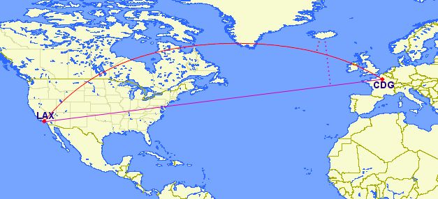
在笛卡尔平面(紫色线)上使用地理坐标确实会产生*非常*错误的答案!使用大圆路线(红线)给出了正确的答案。如果我们将我们的LAX-CDG航班转换为字符串,并使用``geography``计算到冰岛某个点的距离,我们将得到以米为单位的正确答案(召回)。
SELECT ST_Distance(
  ST_GeographyFromText('LINESTRING(-118.4079 33.9434, 2.5559 49.0083)'), -- LAX-CDG
  ST_GeographyFromText('POINT(-22.6056 63.9850)')                        -- Iceland (KEF)
);
502454.906643729
因此,在LAX-CDG航线上,离冰岛最近的距离(从其国际机场测量)是相对较小的502公里。
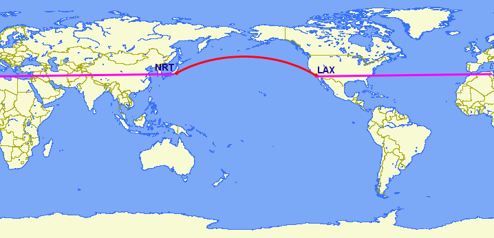
对于跨越国际日期变更线的特征,处理地理坐标的笛卡尔方法完全失效。从洛杉矶到东京最短的大圆航线要穿越太平洋。最短的笛卡尔路线穿过大西洋和印度洋。
SELECT ST_Distance(
  ST_GeometryFromText('Point(-118.4079 33.9434)'),  -- LAX
  ST_GeometryFromText('Point(139.733 35.567)'))     -- NRT (Tokyo/Narita)
    AS geometry_distance,
ST_Distance(
  ST_GeographyFromText('Point(-118.4079 33.9434)'), -- LAX
  ST_GeographyFromText('Point(139.733 35.567)'))    -- NRT (Tokyo/Narita)
    AS geography_distance;
 geometry_distance | geography_distance
-------------------+--------------------
  258.146005837336 |   8833954.76996256
18.1. 使用地理
为了将几何数据加载到地图表中,首先需要将几何投影到EPSG:4326(经度/纬度)中,然后需要将其更改为地理。 ST_Transform(geometry,srid)`函数将坐标转换为地理位置,而:command:`Geography(geometry)`函数或 `::geography`` 后缀将坐标“强制转换”为地理位置。
CREATE TABLE nyc_subway_stations_geog AS
SELECT
  ST_Transform(geom,4326)::geography AS geog,
  name,
  routes
FROM nyc_subway_stations;
在地理表中创建空间索引与在几何表中创建空间索引完全相同:
CREATE INDEX nyc_subway_stations_geog_gix
ON nyc_subway_stations_geog USING GIST (geog);
不同之处在于:地理索引可以正确处理覆盖两极或国际日期变更线的查询,而几何索引则不能。
这里有一个查询,可以找到帝国大厦500米范围内的所有地铁站。
WITH empire_state_building AS (
  SELECT 'POINT(-73.98501 40.74812)'::geography AS geog
)
SELECT name,
  ST_Distance(esb.geog, ss.geog) AS distance,
  degrees(ST_Azimuth(esb.geog, ss.geog)) AS direction
FROM nyc_subway_stations_geog ss,
     empire_state_building esb
WHERE ST_DWithin(ss.geog, esb.geog, 500);
地理类型只有少量本地函数:
ST_AsText(geography) 返回``text``类型
ST_GeographyFromText(text) 返回 ``geography``类型
ST_AsBinary(geography) 返回 ``bytea``类型
ST_GeogFromWKB(bytea) 返回``geography``类型
ST_AsSVG(geography) 返回 ``text``类型
ST_AsGML(geography) 返回 ``text``类型
ST_AsKML(geography) 返回``text``类型
ST_AsGeoJson(geography) 返回``text``类型
:command:`ST_Distance(geography, geography)`返回``double``类型
:command:`ST_DWithin(geography, geography, float8)`返回 ``boolean``类型
:command:`ST_Area(geography)`返回``double``类型
:command:`ST_Length(geography)`返回``double``类型
:command:`ST_Covers(geography, geography)`返回``boolean``类型
:command:`ST_CoveredBy(geography, geography)`返回``boolean``类型
:command:`ST_Intersects(geography, geography)`返回 ``boolean``类型
ST_Buffer(geography, float8)`返回 ``geography` [#Casting_note]_类型
ST_Intersection(geography, geography) 返回``geography`` [#Casting_note]_类型
18.2. 创建地理表
用于创建包含地理列的新表的SQL与用于创建几何表的SQL非常相似。但是,地理包括在创建表时直接指定对象类型的能力。例如:
CREATE TABLE airports (
    code VARCHAR(3),
    geog GEOGRAPHY(Point)
  );

INSERT INTO airports
  VALUES ('LAX', 'POINT(-118.4079 33.9434)');
INSERT INTO airports
  VALUES ('CDG', 'POINT(2.5559 49.0083)');
INSERT INTO airports
  VALUES ('KEF', 'POINT(-22.6056 63.9850)');
在表定义中,GEOGRAPHY(Point) 将机场数据类型指定为点。新的地理字段不会在``geometry_columns``视图中注册。相反,它们被注册在一个名为``geography_columns``的视图中。
SELECT * FROM geography_columns;
          f_table_name    | f_geography_column | srid |   type
--------------------------+--------------------+------+----------
 nyc_subway_stations_geog | geog               |    0 | Geometry
 airports                 | geog               | 4326 | Point
注解
上面的输出中省略了一些列。
18.3. 转换为几何图形
虽然地理类型的基本函数可以处理许多用例,但有时您可能需要访问仅由几何类型支持的其他函数。幸运的是,您可以在地理和几何之间来回转换对象。
PostgreSQL的语法惯例是将``::typename``追加到您希望强制转换的值的末尾。因此,2::text``将把数字2转换为文本字符串'2'。'POINT(0 0)'::geometry``将点的文本表示转换为几何点。
ST_X(point) 函数仅支持几何类型。我们如何从地理位置读取 X 坐标?
SELECT code, ST_X(geog::geometry) AS longitude FROM airports;
 code | longitude
------+-----------
 LAX  | -118.4079
 CDG  |    2.5559
 KEF  |  -21.8628
By appending ::geometry to our geography value, we convert the object to a geometry with an SRID of 4326. From there we can use as many geometry functions as strike our fancy. But, remember -- now that our object is a geometry, the coordinates will be interpreted as Cartesian coordinates, not spherical ones.
18.4. 为什么(不)使用地理
地理坐标是被普遍接受的坐标——每个人都知道经纬度是什么意思,但很少有人知道UTM坐标是什么意思。为什么不一直用地理呢?
首先,如前所述,直接支持地理类型的可用功能(目前)要少得多。您可能需要花费大量时间来解决地理类型的限制。
其次,在球体上的计算比笛卡尔计算要昂贵得多。例如,距离的笛卡尔公式(毕达哥拉斯)涉及一次调用sqrt()。距离的球面公式(Haversine)涉及两次sqrt()调用,一次arctan()调用,四次sin()调用和两次cos()调用。三角函数是非常昂贵的,球面计算涉及到很多三角函数。
结论?
如果您的数据在地理上紧凑的**(包含在一个州,县或市),**使用具有笛卡尔投影的几何类型,这对您的数据有意义。请参阅 http://epsg.io网站,并键入您所在地区的名称,以选择可能的参考系统。
如果你需要用地理上分散的数据集**(覆盖世界的大部分)来测量距离,**使用地理类型。在``geography``中工作节省的应用程序复杂性将抵消任何性能问题。而转换为``geometry`` 可以抵消大多数功能限制。
18.5. 函数列表
ST_Distance(geometry, geometry): 对于几何类型,返回两个几何图形之间的二维笛卡尔最小距离(基于空间参考)(以投影单位表示)。对于地理类型,默认返回两个地理区域之间的球体最小距离(以米为单位)。
ST_GeographyFromText(text):从众所周知的文本表示或扩展 (WKT) 返回指定的地理值。
ST_Transform(geometry, srid):返回一个新的几何图形,其坐标转换为整数参数引用的 SRID。
ST_X: 返回点的 X 坐标,如果不可用则返回 NULL。输入必须是一个点。
ST_Azimuth(geography_A, geography_B): 以弧度为单位返回从A到B的方向。
ST_DWithin(geography_A, geography_B, R):如果A距离B在R米以内返回true。
脚注
