Name
ST_MapAlgebraExpr — Versão de banda raster 2: Cria uma banda raster nova formada pela aplicação de uma operação algébrica válida PostgreSQL nas duas bandas raster de entrada e do tipo de pixel fornecido. A banda 1 de cada raster é assumida se nenhum número de bandas for especificado. O raster resultante será alinhado (escala, inclinação e cantos de pixel) na grade definida pelo primeiro raster e tem sua extensão definida pelo parâmetro "extenttype". O valores para "extenttype" pode ser: INTERSEÇÃO, UNIÃO, PRIMEIRO, SEGUNDO.
Synopsis
raster ST_MapAlgebraExpr(raster rast1, raster rast2, text expression, text pixeltype=same_as_rast1_band, text extenttype=INTERSECTION, text nodata1expr=NULL, text nodata2expr=NULL, double precision nodatanodataval=NULL);
raster ST_MapAlgebraExpr(raster rast1, integer band1, raster rast2, integer band2, text expression, text pixeltype=same_as_rast1_band, text extenttype=INTERSECTION, text nodata1expr=NULL, text nodata2expr=NULL, double precision nodatanodataval=NULL);
Descrição
![[Warning]](../images/warning.png)
|
|
|
ST_MapAlgebraExpr é menosprezado como do 2.1.0. Use ST_MapAlgebra (expression version). |
Cria uma nova banda raster formada pela aplicação válida de uma operação algébrica PostgreSQL definida pela expression no raster de saída (rast). Se nband, band2 não forem especificados, a banda 1 é assumida. O raster resultante será alinhado (escala, inclinação e cantos de pixel) na grade definida pelo primeiro raster. O raster resultante terá de ser definido pelo primeiro raster. O raster resultante terá a extensão definida pelo parâmetro extenttype.
-
expression -
Uma expressão algébrica PostgreSQL envolvendo dois rasters e funções/operadores PostgreSQL definidos que irão elucidar o valor do pixel quando eles se intersectarem. ex.: (([rast1] + [rast2])/2.0)::integer
-
pixeltype -
O tipo de pixel resultante do raster de saída. Deve ser um listado em ST_BandPixelType, deixado de fora ou NULO. Se não passar ou for NULO, usa-se o tipo de pixel do primeiro raster.
-
extenttype -
Controla a extensão do raster resultante
-
INTERSECTION- A extensão do novo raster é a interseção de dois rasters. Este é o padrão. -
UNION- A extensão do novo raster é a união dos dois raster. -
FIRST- A extensão do novo raster é a mesma da do primeiro raster. -
SECOND- A extensão do novo raster é a mesma da do segundo raster.
-
-
nodata1expr -
Uma expressão algébrica envolvendo somente
rast2ou uma constante que define o que retornar quando pixeis derast1são valores nodata e os pixeis rast2 têm valores. -
nodata2expr -
Uma expressão algébrica envolvendo somente
rast1ou uma constante que define o que retornar quando pixeis derast2são valores nodata e os pixeis rast1 têm valores. -
nodatanodataval -
Uma constante numérica para retornar quando os pixeis rast1 e raste2 forem ambos valores nodata.
Se pixeltype passar, o novo raster terá uma banda desse tipo de pixel. Se o tipo de pixel passar NULOou nenhum tipo for especificado, a nova banda raster terá o mesmo tipo de pixel da banda de entrada rast1.
Use o termo [rast1.val] [rast2.val] para referir-se ao valor de pixel das bandas rasters originais e [rast1.x], [rast1.y] etc. para referir-se à posição da coluna/linha dos pixeis.
Disponibilidade: 2.0.0
Exemplo: 2 Interseção de Banda e União
Cria uma nova banda raster 1 a partir da nossa original que é uma função de módulo 2 da banda raster original.
--Create a cool set of rasters --
DROP TABLE IF EXISTS fun_shapes;
CREATE TABLE fun_shapes(rid serial PRIMARY KEY, fun_name text, rast raster);

-- Insert some cool shapes around Boston in Massachusetts state plane meters --
INSERT INTO fun_shapes(fun_name, rast)
VALUES ('ref', ST_AsRaster(ST_MakeEnvelope(235229, 899970, 237229, 901930,26986),200,200,'8BUI',0,0));

INSERT INTO fun_shapes(fun_name,rast)
WITH ref(rast) AS (SELECT rast FROM fun_shapes WHERE fun_name = 'ref' )
SELECT 'area' AS fun_name, ST_AsRaster(ST_Buffer(ST_SetSRID(ST_Point(236229, 900930),26986), 1000),
            ref.rast,'8BUI', 10, 0) As rast
FROM ref
UNION ALL
SELECT 'rand bubbles',
            ST_AsRaster(
            (SELECT ST_Collect(geom)
    FROM (SELECT ST_Buffer(ST_SetSRID(ST_Point(236229 + i*random()*100, 900930 + j*random()*100),26986), random()*20) As geom
            FROM generate_series(1,10) As i, generate_series(1,10) As j
            ) As foo ), ref.rast,'8BUI', 200, 0)
FROM ref;

--map them -
SELECT  ST_MapAlgebraExpr(
        area.rast, bub.rast, '[rast2.val]', '8BUI', 'INTERSECTION', '[rast2.val]', '[rast1.val]') As interrast,
        ST_MapAlgebraExpr(
            area.rast, bub.rast, '[rast2.val]', '8BUI', 'UNION', '[rast2.val]', '[rast1.val]') As unionrast
FROM
  (SELECT rast FROM fun_shapes WHERE
 fun_name = 'area') As area
CROSS JOIN  (SELECT rast
FROM fun_shapes WHERE
 fun_name = 'rand bubbles') As bub
|
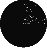
 interseção de mapa algébrico
|
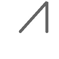
 união de mapa algébrico
|
Exemplo: Revestindo rasters em um quadro como bandas separadas
-- we use ST_AsPNG to render the image so all single band ones look grey --
WITH mygeoms
    AS ( SELECT 2 As bnum, ST_Buffer(ST_Point(1,5),10) As geom
            UNION ALL
            SELECT 3 AS bnum,
                ST_Buffer(ST_GeomFromText('LINESTRING(50 50,150 150,150 50)'), 10,'join=bevel') As geom
            UNION ALL
            SELECT 1 As bnum,
                ST_Buffer(ST_GeomFromText('LINESTRING(60 50,150 150,150 50)'), 5,'join=bevel') As geom
            ),
   -- define our canvas to be 1 to 1 pixel to geometry
   canvas
    AS (SELECT ST_AddBand(ST_MakeEmptyRaster(200,
        200,
        ST_XMin(e)::integer, ST_YMax(e)::integer, 1, -1, 0, 0) , '8BUI'::text,0) As rast
        FROM (SELECT ST_Extent(geom) As e,
                    Max(ST_SRID(geom)) As srid
                    from mygeoms
                    ) As foo
            ),
   rbands AS (SELECT ARRAY(SELECT ST_MapAlgebraExpr(canvas.rast, ST_AsRaster(m.geom, canvas.rast, '8BUI', 100),
                 '[rast2.val]', '8BUI', 'FIRST', '[rast2.val]', '[rast1.val]') As rast
                FROM mygeoms AS m CROSS JOIN canvas
                ORDER BY m.bnum) As rasts
                )
          SELECT rasts[1] As rast1 , rasts[2] As rast2, rasts[3] As rast3, ST_AddBand(
                    ST_AddBand(rasts[1],rasts[2]), rasts[3]) As final_rast
            FROM rbands;
|
 rast1
|
 rast2
|
|
 rast3
|
 final_rast
|
Exemplo: Cobre 2 metros de limite das parcelas selecionadas sobre uma área imaginária
-- Create new 3 band raster composed of first 2 clipped bands, and overlay of 3rd band with our geometry
-- This query took 3.6 seconds on PostGIS windows 64-bit install
WITH pr AS
-- Note the order of operation: we clip all the rasters to dimensions of our region
(SELECT ST_Clip(rast,ST_Expand(geom,50) ) As rast, g.geom
    FROM aerials.o_2_boston AS r INNER JOIN
-- union our parcels of interest so they form a single geometry we can later intersect with
        (SELECT ST_Union(ST_Transform(geom,26986)) AS geom
          FROM landparcels WHERE pid IN('0303890000', '0303900000')) As g
        ON ST_Intersects(rast::geometry, ST_Expand(g.geom,50))
),
-- we then union the raster shards together
-- ST_Union on raster is kinda of slow but much faster the smaller you can get the rasters
-- therefore we want to clip first and then union
prunion AS
(SELECT ST_AddBand(NULL, ARRAY[ST_Union(rast,1),ST_Union(rast,2),ST_Union(rast,3)] ) As clipped,geom
FROM pr
GROUP BY geom)
-- return our final raster which is the unioned shard with
-- with the overlay of our parcel boundaries
-- add first 2 bands, then mapalgebra of 3rd band + geometry
SELECT ST_AddBand(ST_Band(clipped,ARRAY[1,2])
    , ST_MapAlgebraExpr(ST_Band(clipped,3), ST_AsRaster(ST_Buffer(ST_Boundary(geom),2),clipped, '8BUI',250),
     '[rast2.val]', '8BUI', 'FIRST', '[rast2.val]', '[rast1.val]') ) As rast
FROM prunion;
|
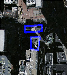 As linhas azuis são os limites das parcelas selecionadas
|
Veja também
ST_MapAlgebraExpr, ST_AddBand, ST_AsPNG, ST_AsRaster, ST_MapAlgebraFct, ST_BandPixelType, ST_GeoReference, ST_Value, ST_Union, ST_Union